
|
River Sarasvati (Factfile)
·
Mother of all Rivers
(Sarawati,Sapthati,Sindhumata)
·
Partly survives flowing between Satadru and
Yamuna
·
Identified with Harakhwati of Avesta or Halmand
or with Hakra rivers
·
In Rigveda,three epithets used – Ambitame,Devitame
and Naditame
Dhrisadvati
·
No connection with rivers of Indus group
·
Described as Southern and Eastern boundries of
the region what was known as Brahmavarta ( Brahmavarta of the early Vedic times
was an area bounded by two rivers. Saraswati and Drisadwati. both now invisible..)
·
It has been identified with Chautang
|
Missing of a
prominent river from the map is not a mystery; it is quite natural and is
attributable to environmental changes. Judged in the broader perspective of
geological evolution; disappearance of rivers, shifting of their courses,
capture of one river by another, slow drying up of river beds, are all normal
responses to tectonism, earthquakes, climatic changes and other natural events.
Some recent
examples are; Oxus river in central Asia has disappeared, Jordan river no more
flows through Jordan as it dries up before entering Jordan, Jhelum changed its
course in 1552-55 AD and Beas changed its course during 1996 flash floods. However, upto
the middle of 20th century, in the absence of any credible scientific research
reports, history of India was being written on the basis of linguistic theories
and guesswork and our historians just presumed that
Sarasvati river was only mythical, a mere imagination. However,
methods based on linguistics and politics are progressively giving way to
methods based on science and technology e.g. satellite imagery, archaeology,
geology, geophysics, glaceology and oceanography etc. and the role of ecology
in the rise and fall of civilizations/ creation and disappearance of rivers is
being increasingly accepted and appreciated.
The results of
scientific research carried out during last 40 years have proved, fairly beyond
doubt, that Sarasvati River was not a myth but a reality and that it was a
mighty river which originated from the Himalayas and met the Arabian Sea in the
Runn of Kuchchh after flowing through Haryana, Punjab, Rajasthan & Gujarat
states of India and Bahawalpur & Sind districts of Pakistan. These
scientific evidences gathered include: -
|
1. Study of global climatic changes – Ecological dynamics model,
which gives ecological reasons for origin, development and decay of Sarasvati
river.
2. Pictures taken by LANDSAT(USA), Indian Remote Sensing
Satellites [IRS-1C], French SPOT Satellites and Radar imagery from European
Remote Sensing Satellites (ERS ½), which provide evidence about the flow,
migration and decay of Sarasvati River.
3. References in most ancient Sanskrit manuscripts indicating
different phases of development, migration and disappearance of Sarasvati
River, which corroborate the satellite imagery.
4. Geological and hydrological evidences gathered by the
geologists – listing the palaeochannels reflecting different stages of
migration and decay of Sarasvati river.
5. Research reports from geophysicists, geomorphologists,
climatologists, oceanographers and glaciologists etc.
6. Archaeological reports including marine archaeology reports.
7. Research carried out by the Rajasthan State Groundwater Board
for assessing groundwater potential in Rajasthan through Hydrological
drilling and dating.
|
Mention of River Saraswati in Literature :
These
different stages in the northwest migration of River Sarasvati do get broadly
reflected in the hymns of Vedas and other ancient manuscripts – the early
stages agree with the description in Rigveda, Middle stages with the hymns of
Yayurveda/Atharvaveda whereas the last stages coincide with the description in
Mahabharata.
In Rig Veda,
Sarasvati is described as the mightiest river – “Seven sistered, sprung from three-fold sources”
[6:61:12]. Again it is described as “Saptathi Sindhumata” i.e., mother of seven
rivers strongly flowing and swelling in volumes (7:36:6). Prayers are offered
to ten rivers including Sarasvati, the names are mentioned sequentially– “O Ganga, Yamuna, Sarasvati, Sutlej, Ravi,
Chenab, Marudvrudha, Jhelam, Sohana and Vyas and other rivers listen to our
eulogy (10:75:5)”.
In later part
of Rig Veda, Sarasvati, Sarayu and Sindhu are worshipped as three mighty rivers
[10:64:9].
Therefore, it does not appeal to reason that only one
out of seven rivers, one out of ten rivers or one out of three rivers would be
imaginary and mythical whereas others were and are a reality. It is true that
the descriptions of Sarasvati river in vedic literature are intervined with
mythological events but so are the descriptions of Ganges. Therefore, instead
of denying the existence of Sarasvati river, we should separate the poetic
imagination from hard facts.
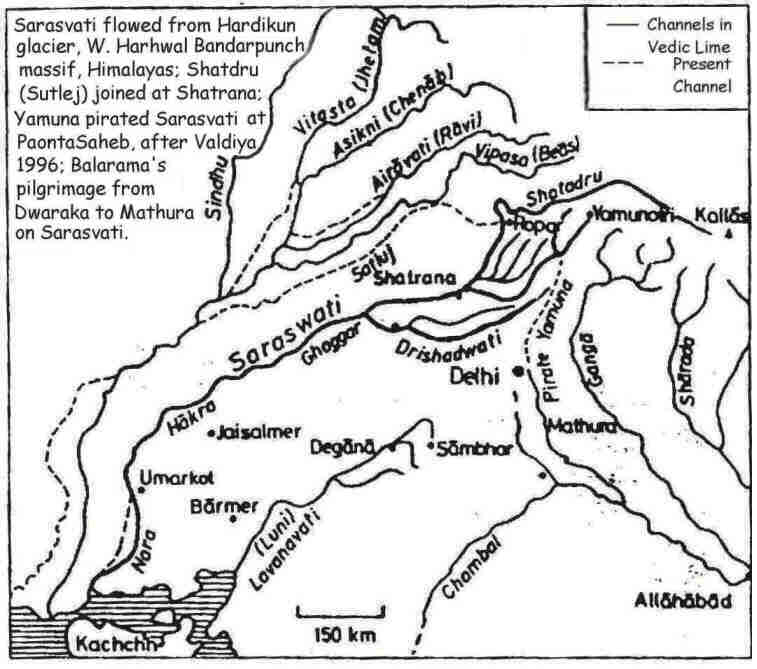
In Yayurveda, it is said that five equally celebrated rivers merged
with the mighty Sarasvati. The same Sarasvati got divided into five glorified
flows in the country. Five tributaries were Drishadvati, Satudri (Sutlej),
Chandrabhaga (chenab), Vipasa (Vyas) and Iravati (Ravi). The five
distributaries are named in Skanda Purana as Harini, Vjrini, Hyunk, Kapila and
Sarasvati. Thus, whereas Sarasvati had 7 tributaries, including Yamuna, during
Rigveda era, it was left with only 5 tributaries (minus Yamuna) by the time
Yayurveda was compiled.
Mahabharata
gives a clear geographical account of Sarasvati becoming a non-perennial river
vanishing and re-appearing in the deserts [3:80:118 & 9:36:1], surviving in
the form of a number of lanes e.g. Brahmasar, jyotisar, Kaleswar (in Haryana),
Katasar, Pandusar & Ravisar (in Rajasthan). Kurukshetra is described as
located in the south of Sarasvati and north of Drishadvati [Mbh. 3:81:115]
Thus, pictures
taken by Remote Earth Sensing Satellites Corroborate the references to location
and course of Sarasvati River in ancient Vedic literature.
|
Additional
Reading -- Geographical Evidence of various topographics in the Vedas !!!
The geographical
evidence as to be found in the hymns of Vedas throws some light on the course
of Indo-Aryan migration and the origin of Hinduism. Whether the Indo-Aryans
came from Central Asia or not depends largely on the interpretation of the
geographical allusions in the Rig and Yajur Vedas. The hymns in praise of
rivers in the 10th blcok are interesting. The author while singing the
greatness of the Sindhu enumerates at least 19 rivers including the Ganges.
The fifth Stanza gives a list of 10 streams, small and great-Ganges, Yamuna,
Saraswati, Satluj, Ravi, Chenab, Jhelum, Maruwardwan (in J&K), Sushoma
(Rowalpindi District) and probably Kanshi in the same district. This system
of rivers did not remain the Saraswati. The existing delta of the Indus has
been formed since the time of Alexander the Great.
The Vedic hymns reveal
the initial Aryan settlements in India : western tributaries of the Indus,
the Gomti (modern Gomal) the Krumu (modern Kurram) and the Kubha (modern
Kabul). The one river mentioned in the North of Kabul is Suvastu (modern
swat).
But the main focus
of the Rig Vedic settlements was in the Punjab and the Delhi region. When the
Rig-Vedic hymns were compiled the focus of Aryan settlement was the region
between the Yamuna and the Sutlaj, south of modern Ambala and laong the upper
course of river Saraswati. The most frequently mentioned rivers are the
Sindhu (Indus), the Sarasvati (modern Sarsuti), the Drishadvati (modern
Chitang), and the five streams of the Punjab.
Regarding the
other geographical features, the Vedic poets knew the Himalayas but not the
land south of Yamuna, since they did not mention the Vindhayas, In the east
also the Aryans did not expand beyond Yamuna; for the river Ganga is
mentioned only once in one late hymn.
And possibly, the Aryans had no knowledge of
the oceans since the word 'samudra' in the Vedic period meant a pool of
water. But the later Vedic knowledge shows that the Aryans knew the two seas,
the Himalayas and the Vindhyan mountainas and generally the entire Indo-Gangetic
plain.
The Aryans used
various kinds of pottery and the sites where the painted grey were are found,
confirm the Aryan settlements. The Vedic texts show that the Aryans expanded
from the Punjab over the whole of western Uttar Pradesh covered by the
Ganga-Yamuna Doab. The Bharatas and
Purus known as Kuru people first lived between Sarasvati and Drishadvati just
on the fringe of the Doab. Soon the Kurus
occupied Delhi and the Upper portion of the doab, that is the area called
Kurukshetra, After this event, the Kurus joined with the people called
Panchalas who occupied the middle portion of the Doab or the moder districts
of bareilly Dadaun and Farrukabad. It was the Kuru-Panchalas who had set up
their capital at Hastinapur situated in the district of Meerut. Later the
Kauravas and the Pandavas belonging to the same Kuru clan fougth out a battle
which led to the extinction of the Kuru clan.
And by 600 B.C.
the Aryans spread from the Doab further east to Kosala in Eastern U.P. and
Vedeha in north Bihar. The former town is associated with the story of
Ramchandra, but it is not mentioned in Vedic literature.
|
|
Exploration of Saraswati River
|
|
Ministry
of Water Resources has no plans to explore the underground flowing river
Saraswati and exploit its water. However, Oil & Natural Gas Corporation
(ONGC) has taken up a project named “ONGC Project Saraswati” for exploration
of deep ground water resources in drought prone arid/semi arid regions of
India with the objective to investigate
(a) Existence of situations akin to
Libyan Great Manmade River Project and their exploitation in drought prone
arid/semi arid regions of India.
(b) Alternatively, identification of deeper
aquifers for exploitation of groundwater in drought prone arid/semi arid
regions otherwise not tapped by agencies such as State Groundwater Boards and
central ground water bodies.
ONGC has informed that based on vertical electrical sounding survey result, one of the locations identified was taken up for drilling and the well (Saraswati-1) near Jaisalmer town has been drilled up to 554 m and produced reasonably less saline water (3050 milligrams per litres ) at the rate of 76000 litres per hour. |